Historic photos from around The Junction, TorontoAlso known as the West Toronto Diamond, The Junction is centred around Dundas Street West and Keele Street. In the mid-1850's most of the area was part of the Keele family Carlton Race Course, home of the first Queen's Plate. It has long been an industrial neighbourhood, where the CP east-west main line crosses the CN tracks. It is home to the Ontario Stockyards and many meat packing companies. It was the last dry area of Toronto, and is now known for its many restaurants and bars along Dundas Street.List of all areas in Toronto or take a look at the historic photos by date. New! You can now access the photos by street address A subset of the photos have also been arranged by subject. |
| 1893 | 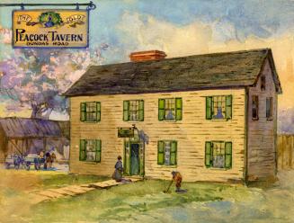 | The Old Peacock Tavern (before moving north and becoming a hotel), Dundas St. W., n.w. cor. Brad St. 133 years ago - 1893 - The Junction Link to archive record - Map location (From the Toronto Public Library) |
| 1901 | Houses 97-105 Perth Ave (still standing) west of Bloor St W crossing of Grand Trunk Railway (G.T.R.). (main line) and C.P.R. (Canadian Pacific Railway) 125 years ago - Tuesday, December 3, 1901 - The Junction at 1475 Bloor Street West Max temp: -2.8°C - Min temp: -10.0°C (weather details) Link to archive record - Map location (From the Library and Archives Canada) |
|
| 1910 |  | Royce Avenue (Dupont Street) west at Perth Ave 116 years ago - Friday, September 30, 1910 - The Junction Max temp: 22.8°C - Min temp: 7.8°C (weather details) Link to archive record - Map location (From the City of Toronto Archives) |
| 1911 | | White picket fence and gate northeast corner Weston Road and St. Clair Avenue 115 years ago - Thursday, August 31, 1911 - The Junction at 1828 St Clair Ave West n.e. corner at Old Weston Road Max temp: 21.1°C - Min temp: 10.0°C (weather details) Link to archive record - Map location (From the City of Toronto Archives) |
| 1912 |  | Peacock Hotel on Dundas Street West at Royce Avenue (Dupont) (Categorized under: Hotels ) 114 years ago - Tuesday, September 17, 1912 - The Junction Max temp: 19.4°C - Min temp: 6.7°C (weather details) Link to archive record - Map location (From the City of Toronto Archives) |
| 1913 |  | Keele and Humberside Park (now Baird Park) 113 years ago - Tuesday, February 18, 1913 - The Junction Max temp: -1.7°C - Min temp: -13.3°C (weather details) Link to archive record - Map location (From the City of Toronto Archives) |
| 1913 | | Soccer fields in Uttley Park (now Oakmount Park) 113 years ago - Wednesday, October 15, 1913 - The Junction Max temp: 18.3°C - Min temp: 5.6°C (weather details) Link to archive record - Map location (From the City of Toronto Archives) |
| 1913 |  | Keele Street Park (now Oakmount Park?) 113 years ago - Wednesday, October 15, 1913 - The Junction Max temp: 18.3°C - Min temp: 5.6°C (weather details) Link to archive record - Map location (From the City of Toronto Archives) |
| 1915 | 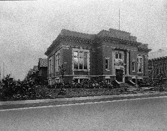 | Toronto Public Library - Edwardian Classicism Annette Branch built with a Carnegie grant, at Medland St designed by local Ellis & Connery 111 years ago - 1915 - The Junction Link to archive record - Map location (From the Toronto Public Library) |
| 1916 |  | Maple Leaf Milling Co. and Campbell Flour Mills Co. Ltd. 110 years ago - 1916 - The Junction Link to archive record - Map location (From the City of Toronto Archives) |
| 1919 |  | Sterling Road tower - tallest in Canada until Royal York - Tower Automotive/Algoods/Northern Aluminum Comp 107 years ago - 1919 - The Junction Link to archive record - Map location (From the City of Toronto Archives) |
| 1923 | | Looking north on Keele at Humberside, with Baird Park on the right (incorrect Archive details) 103 years ago - Friday, March 9, 1923 - The Junction at 275 Keele Street at Humberside Avenue Max temp: -1.1°C - Min temp: -13.9°C - 1.0cm of snowfall (weather details) Link to archive record - Map location (From the City of Toronto Archives) |
| 1923 | | Dundas Street bridge west to Sterling Road 103 years ago - Wednesday, March 21, 1923 - The Junction Max temp: 10.6°C - Min temp: -2.8°C (weather details) Link to archive record - Map location (From the City of Toronto Archives) |
| 1923 | | Sterling Road looking north from Dundas Street West 103 years ago - Wednesday, March 21, 1923 - The Junction Max temp: 10.6°C - Min temp: -2.8°C (weather details) Link to archive record - Map location (From the City of Toronto Archives) |
| 1923 | | Royce Avenue (Dupont St.) and Dundas Street railway crossing looking east 103 years ago - Friday, April 6, 1923 - The Junction Max temp: 11.1°C - Min temp: 0.0°C (weather details) Link to archive record - Map location (From the City of Toronto Archives) |
| 1923 | | Keele St, south, from Hirons St 103 years ago - Monday, October 8, 1923 - The Junction Max temp: 15.0°C - Min temp: 1.7°C (weather details) Link to archive record - Map location (From the City of Toronto Archives) |
| 1923 | Beaver Theatre (1913-1961) on the right with sign for the silent film Bella Donna - Dundas Street looking west from Medland Street (Categorized under: West end theatres ) 103 years ago - Thursday, November 15, 1923 - The Junction at 2942 Dundas Street West Link to archive record - Map location (From the Library and Archives Canada) |
|
| 1923 | | Laying streetcar tracks on Dundas, looking west, from Pacific 103 years ago - Wednesday, November 28, 1923 - The Junction Max temp: 2.8°C - Min temp: 0.6°C (weather details) Link to archive record - Map location (From the City of Toronto Archives) |
| 1923 | | Keele Street subway south from Junction Road - ad for the Royal Winter Fair Nov 20 - 28th 103 years ago - Wednesday, November 28, 1923 - The Junction at 419 Keele Street south of Junction Road Max temp: 2.8°C - Min temp: 0.6°C (weather details) Link to archive record - Map location (From the City of Toronto Archives) |
| 1923 | | Mavety Theatre on Dundas Street, looking west (Categorized under: West end theatres ) 103 years ago - Monday, December 3, 1923 - The Junction Max temp: 5.0°C - Min temp: 1.7°C (weather details) Link to archive record - Map location (From the City of Toronto Archives) |
| 1924 | Heydon House Hotel in background of TTC Foote Mixer - Old Weston Road just north of St. Clair (Categorized under: Heydon House hotel ) 102 years ago - Wednesday, January 16, 1924 - The Junction at 360 Old Weston Road at St Clair Ave W Link to archive record - Map location (From the Library and Archives Canada) |
|
| 1925 | | Heydon House Hotel with a billboard location just east (Categorized under: Heydon House hotel ) 101 years ago - 1925 - The Junction at 360 Old Weston Road Link to archive record - Map location (From the City of Toronto Archives) |
| 1925 | | Heydon House Hotel with Borden's St. Charles Milk bilboard ad (Categorized under: Heydon House hotel ) 101 years ago - 1925 - The Junction at 360 Old Weston Road Link to archive record - Map location (From the City of Toronto Archives) |
| 1926 | | Southeast corner Keele Street and Junction Road 100 years ago - Saturday, January 30, 1926 - The Junction at 450 Keele Street s.e. corner at Junction Road Link to archive record - Map location (From the City of Toronto Archives) |
| 1927 | | Heydon House Hotel, northwest corner of Old Weston Road and St. Clair Avenue (Categorized under: Heydon House hotel ) 99 years ago - Wednesday, March 16, 1927 - The Junction Max temp: 13.3°C - Min temp: -0.6°C (weather details) Link to archive record - Map location (From the City of Toronto Archives) |
| 1929 | | 11:20AM Lansdowne Avenue - Royce Avenue crossing with train waiting 97 years ago - Thursday, November 14, 1929 - The Junction Max temp: 7.2°C - Min temp: 6.1°C (weather details) Link to archive record - Map location (From the City of Toronto Archives) |
| 1931 | | St. Clair Avenue west to Keele Street 95 years ago - Thursday, July 9, 1931 - The Junction Max temp: 25.6°C - Min temp: 13.9°C (weather details) Link to archive record - Map location (From the City of Toronto Archives) |
| 1932 | | Subway - Royce Ave, east of Dundas 94 years ago - Saturday, April 23, 1932 - The Junction Max temp: 9.4°C - Min temp: 2.2°C (weather details) Link to archive record - Map location (From the City of Toronto Archives) |
| 1932 | | Canadian General Electric Co on Lansdowne Ave, north of Royce Ave (Dupont) 94 years ago - Saturday, April 23, 1932 - The Junction Max temp: 9.4°C - Min temp: 2.2°C (weather details) Link to archive record - Map location (From the City of Toronto Archives) |
| 1932 | | Royce Ave subway, looking west, to northern approach 94 years ago - Monday, April 25, 1932 - The Junction Max temp: 6.1°C - Min temp: 0.6°C (weather details) Link to archive record - Map location (From the City of Toronto Archives) |
| 1932 | | Western approach to Royce Ave subway, looking north, (Executive Department) 94 years ago - Monday, April 25, 1932 - The Junction Max temp: 6.1°C - Min temp: 0.6°C (weather details) Link to archive record - Map location (From the City of Toronto Archives) |
| 1932 | | New Street at Campbell Milling Company 94 years ago - Friday, December 9, 1932 - The Junction Max temp: -5.6°C - Min temp: -9.4°C (weather details) Link to archive record - Map location (From the City of Toronto Archives) |
| 1934 | | Bloor St, looking east, at Sterling Rd, to Symington Ave, case #1338, (Legal Department) 92 years ago - Friday, March 2, 1934 - The Junction Max temp: 4.4°C - Min temp: -1.7°C (weather details) Link to archive record - Map location (From the City of Toronto Archives) |
| 1934 | | Case #1338, Bloor St, east of Symington, looking wast to Symington and Sterling Rd, (Legal Department) 92 years ago - Friday, March 2, 1934 - The Junction Max temp: 4.4°C - Min temp: -1.7°C (weather details) Link to archive record - Map location (From the City of Toronto Archives) |
| 1934 | | Rear of Service Station Dundas Street south side opposite Sterling Road 92 years ago - Tuesday, October 30, 1934 - The Junction Max temp: 8.3°C - Min temp: 1.1°C (weather details) Link to archive record - Map location (From the City of Toronto Archives) |
| 1935 | | No. 336 Annette Street, Wm. Wilson residence, Annette Street west of Laws Street 91 years ago - Tuesday, March 26, 1935 - The Junction Max temp: 6.1°C - Min temp: -2.8°C (weather details) Link to archive record - Map location (From the City of Toronto Archives) |
| 1936 | | Dundas St, looking west, to Sterling Road; photo taken 4 feet south of north curb, 113 feet east of hydro pole on north-east corner of Sterling Road and Dundas Street, (Legal Department) 90 years ago - Saturday, September 12, 1936 - The Junction Max temp: 25.6°C - Min temp: 18.9°C (weather details) Link to archive record - Map location (From the City of Toronto Archives) |
| 1937 | | Dundas Street looking southeast from west of Sterling Road 89 years ago - Tuesday, June 1, 1937 - The Junction Max temp: 28.3°C - Min temp: 16.1°C (weather details) Link to archive record - Map location (From the City of Toronto Archives) |
| 1937 | | Dundas Street east across Sterling Road 89 years ago - Tuesday, June 1, 1937 - The Junction Max temp: 28.3°C - Min temp: 16.1°C (weather details) Link to archive record - Map location (From the City of Toronto Archives) |
| 1942 | 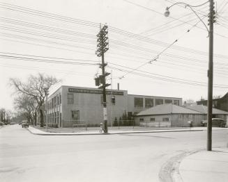 | IBM factory, Campbell Ave., s.w. cor. Dupont St. (trolly wires suggest later than 1942 though) 84 years ago - 1942 - The Junction Link to archive record - Map location (From the Toronto Public Library) |
| 1942 | | Fire escape and car in alley along the side of 215 Mavety Street 84 years ago - Thursday, January 15, 1942 - The Junction at 215 Mavety Street just south of Dundas Street West Max temp: 1.7°C - Min temp: -8.3°C - 0.5cm of snowfall (weather details) Link to archive record - Map location (From the City of Toronto Archives) |
| 1943 | | Peacock Hotel with ads for Face-Elle Tissue, Toronto Conservatory of Music, C.F.R.B. (Categorized under: Hotels ) 83 years ago - 1943 - The Junction at 2760 Dundas Street West Link to archive record - Map location (From the City of Toronto Archives) |
| 1948 | 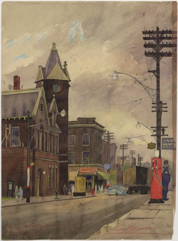 | Painting by James Blomfield of Dundas and Keele St - West Toronto Junction Town Hall (now demolished) 78 years ago - 1948 - The Junction Link to archive record - Map location (From Archives of Ontario) |
| 1952 | | Front of 310 Keele Street 74 years ago - Tuesday, February 19, 1952 - The Junction Max temp: -3.3°C - Min temp: -9.4°C (weather details) Link to archive record - Map location (From the City of Toronto Archives) |
| 1952 | | Back of 310 Keele Street 74 years ago - Tuesday, February 19, 1952 - The Junction at 310 Keele Street Max temp: -3.3°C - Min temp: -9.4°C (weather details) Link to archive record - Map location (From the City of Toronto Archives) |
| 1954 | 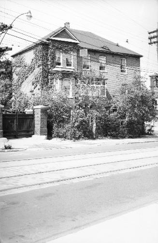 | Subway Hotel (then the Keele Hotel), Keele St., s.w. cor. Vine Ave. 72 years ago - 1954 - The Junction Link to archive record - Map location (From the Toronto Public Library) |
| 1955 | 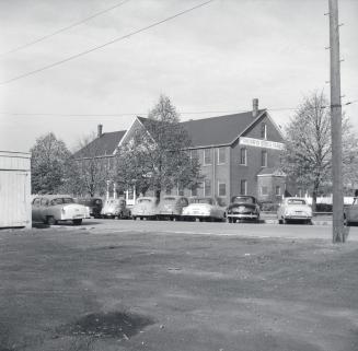 | Union Stock Yards (then called Ontario Stock Yards) Keele St., s.w. cor. St. Clair Ave. W. 71 years ago - 1955 - The Junction Link to archive record - Map location (From the Toronto Public Library) |
| 1955 | 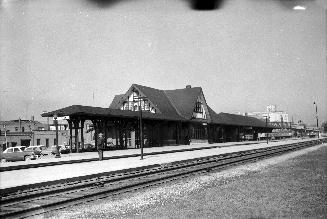 | West Toronto Railway Station (C.P.R.), Old Weston Road, e. side, n. of Dundas St. W 71 years ago - Saturday, April 9, 1955 - The Junction Max temp: 22.8°C - Min temp: 3.3°C (weather details) Link to archive record - Map location (From the Toronto Public Library) |
| 1955 | 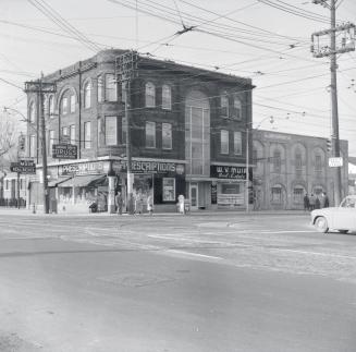 | Heydon House Hotel - then George Smith Drugs and W.V. Muir Real Estate (Categorized under: Heydon House hotel --- Heydon House htel ) 71 years ago - Sunday, November 20, 1955 - The Junction Max temp: 3.9°C - Min temp: -3.9°C (weather details) Link to archive record - Map location (From the Toronto Public Library) |
| 1956 | 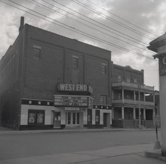 | West End Theatre (previously the Mavety Theatre, then Mavety Hall) showing Tender Trap & Square Jungle (Categorized under: West end theatres ) 70 years ago - 1956 - The Junction at 215 Mavety Street just south of Dundas Street West Link to archive record - Map location (From the Toronto Public Library) |
| 1956 | 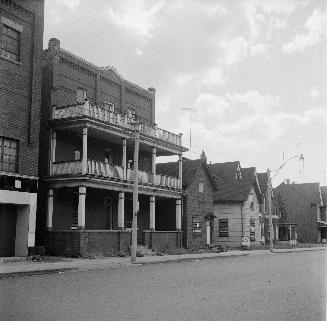 | James Robinson Mavety St. CPR boarding house - nicknamed 'Dog & Pot' - a smallpox epidemic started here 70 years ago - Tuesday, September 11, 1956 - The Junction at 213 Mavety Street (approx.) south of Dundas Street West Max temp: 21.7°C - Min temp: 13.9°C (weather details) Link to archive record - Map location (From the Toronto Public Library) |
| 1957 | 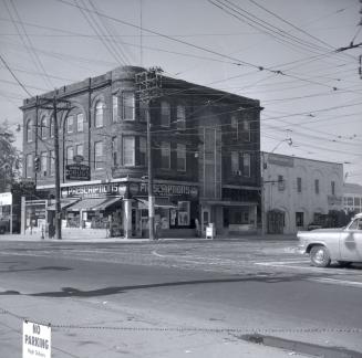 | Heydon House, Old Weston Road., northwest corner St. Clair Avenue W (Categorized under: Heydon House hotel ) 69 years ago - Monday, October 14, 1957 - The Junction at 360 Old Weston Rd n.w. corner at St. Clair Ave West Link to archive record - Map location (From the Toronto Public Library) |
| 1958 | | Royce Avenue Presbyterian Church 1543-1551 Dupont Street (at Perth) 68 years ago - Thursday, October 23, 1958 - The Junction Max temp: 15.0°C - Min temp: 11.7°C (weather details) Link to archive record - Map location (From the City of Toronto Archives) |
| 1983 | | Heydon House northwest corner building detail - name in the base of the tower (Categorized under: Heydon House hotel ) 43 years ago - Saturday, April 23, 1983 - The Junction at 360 Old Weston Road Link to archive record - Map location (From the City of Toronto Archives) |
| 1983 | | Heydon House - distinctive tower long gone (Categorized under: Heydon House hotel ) 43 years ago - Saturday, April 23, 1983 - The Junction at 360 Old Weston Road Link to archive record - Map location (From the City of Toronto Archives) |
| 1983 | | 1867 Heydon House corner with no turret, St. Clair at Old Weston Road, northwest corner (Categorized under: Heydon House hotel ) 43 years ago - Saturday, April 23, 1983 - The Junction at 360 Old Weston Road Link to archive record - Map location (From the City of Toronto Archives) |
| 1983 | | Looking up at corner of Heydon House, St. Clair at Old Weston Road, northwest corner, (Categorized under: Heydon House hotel ) 43 years ago - Saturday, April 23, 1983 - The Junction at 360 Old Weston Road Link to archive record - Map location (From the City of Toronto Archives) |
| 1983 | 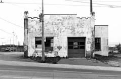 | Keele St and St Clair Ave W, N/E corner - Supertest station in the 1950s 43 years ago - Saturday, November 5, 1983 - The Junction Max temp: 5.0°C - Min temp: 0.2°C (weather details) Link to archive record - Map location (From Collations Flickr stream) |
| 2002 | | Humberside Collegiate Institute auditorium with 1925 mural by Group of Seven painter Arthur Lismer (Categorized under: Schools ) 24 years ago - Sunday, May 26, 2002 - The Junction at 280 Quebec Ave Link to archive record - Map location (From the City of Toronto Archives) |