Historic photos from around Sherwood Park, TorontoNamed for the park at the east end of the neighbourhood, the Sherwood Park neighbourhood runs east from Yonge Street tapering to a narrow stretch at Bayview Ave along Burke Brook. The property south of Blythwood was originally the Stibbard farm, and the park itself was originally known as Waterworks Park, as it was one of two water sources for North Toronto (you can find a 1934 photo of the Pumping Station, below).Along with the baseball diamond and children's play area and waiting pool, the park includes a small section of the Great lakes-St. Lawrence Forest, including white pine, hemlock, beech, oak, and sugar maple - some of the trees date as far back as the 1850's! Ongoing volunteer efforts, working together with the City of Toronto Parks and Recreation Department are ensuring that the forest survives, and thrives.
List of all areas in Toronto or take a look at the historic photos by date. New! You can now access the photos by street address A subset of the photos have also been arranged by subject. |
| 1907 | 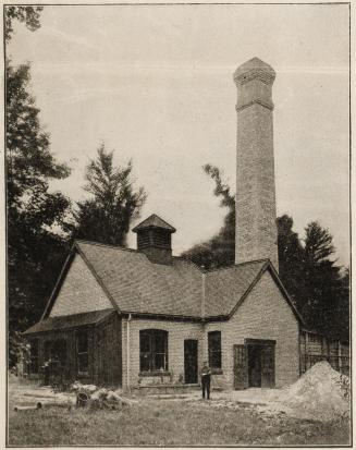 | North Toronto Pumping Station, Waterworks Park (now Sherwood Park) east of Mount Pleasant Road 119 years ago - Sunday, September 15, 1907 - Sherwood Park at 190 Sherwood Ave east of Mount Pleasant Road Link to archive record - Map location (From the Toronto Public Library) |
| 1907 | 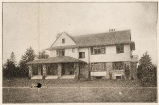 | J. F. H. Ussher House, Blythwood Road, southeast corner of Mount Pleasant Road, Toronto, Ontario 119 years ago - Sunday, September 15, 1907 - Sherwood Park at 223 Blythwood Road s.e. corner at Mount Pleasant Road Link to archive record - Map location (From the Toronto Public Library) |
| 1920 |  | Sherwood Park comfort station 106 years ago - 1920 - Sherwood Park at 190 Sherwood Ave west of Bayview Ave Link to archive record - Map location (From the City of Toronto Archives) |
| 1922 |  | River and hills north of Sherwood Park 104 years ago - Saturday, December 9, 1922 - Sherwood Park at 190 Sherwood Ave west of Bayview Ave Max temp: 3.3°C - Min temp: -5.6°C (weather details) Link to archive record - Map location (From the City of Toronto Archives) |
| 1925 |  | Sherwood Park - kids tobogganing and winter sledding 101 years ago - Saturday, February 14, 1925 - Sherwood Park at 190 Sherwood Ave west of Bayview Ave Max temp: 0.6°C - Min temp: -8.9°C (weather details) Link to archive record - Map location (From the City of Toronto Archives) |
| 1925 | | Sherwood Park - tobogganing on Valentines Day 101 years ago - Saturday, February 14, 1925 - Sherwood Park at 190 Sherwood Ave west of Bayview Ave Max temp: 0.6°C - Min temp: -8.9°C (weather details) Link to archive record - Map location (From the City of Toronto Archives) |
| 1934 | | Sherwood Park, old North Toronto Pumping Station 92 years ago - Thursday, June 28, 1934 - Sherwood Park at 190 Sherwood Ave west of Bayview Ave Max temp: 27.8°C - Min temp: 14.4°C (weather details) Link to archive record - Map location (From the City of Toronto Archives) |
| 1937 |  | 2707 Yonge Street, old mud and straw brick house, east side, north of Blythwood Road 89 years ago - Monday, May 3, 1937 - Sherwood Park at 2707 Yonge Street Max temp: 23.3°C - Min temp: 10.0°C (weather details) Link to archive record - Map location (From the City of Toronto Archives) |
| 1943 | 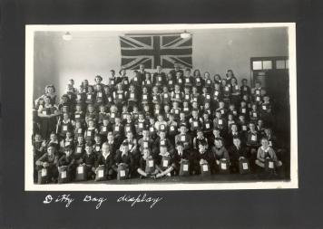 | Blythwood Elementary school - Ditty Bag collection for WWII soldiers (Categorized under: Schools ) 83 years ago - 1943 - Sherwood Park at 2 Strathgowan Crescent north of Blythwood Road Link to archive record - Map location |
| 1944 | 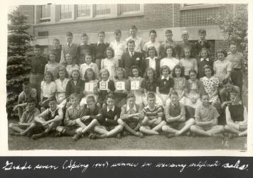 | Blythwood Elementary school - Grade seven (Spring 1944) winners in war savings certificate sales (Categorized under: Schools ) 82 years ago - 1944 - Sherwood Park at 2 Strathgowan Crescent north of Blythwood Road Link to archive record - Map location |
| 1945 | 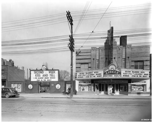 | Circle Theatre marquee at 2567 Yonge Street (Categorized under: Midtown theatres ) 81 years ago - 1945 - Sherwood Park at 2567 Yonge Street Link to archive record - Map location (From Archives of Ontario) |
| 1946 |  | Blythwood Road grading and paving - looking west from Strathgowan Crescent up towards Mount Pleasant 80 years ago - Tuesday, January 22, 1946 - Sherwood Park Max temp: -4.4°C - Min temp: -13.9°C (weather details) Link to archive record - Map location (From the City of Toronto Archives) |
| 1946 | | Blythwood Road grading and paving - looking east? 80 years ago - Tuesday, January 22, 1946 - Sherwood Park Max temp: -4.4°C - Min temp: -13.9°C (weather details) Link to archive record - Map location (From the City of Toronto Archives) |
| 1946 |  | Blythwood Road grading and paving - looking west up the hill to Mount Pleasant 80 years ago - Tuesday, January 22, 1946 - Sherwood Park Max temp: -4.4°C - Min temp: -13.9°C (weather details) Link to archive record - Map location (From the City of Toronto Archives) |
| 1946 | | Blythwood Road grading and paving - small outbuildings in the ravine hills 80 years ago - Tuesday, January 22, 1946 - Sherwood Park Max temp: -4.4°C - Min temp: -13.9°C (weather details) Link to archive record - Map location (From the City of Toronto Archives) |
| 1946 | | Blythwood Road grading and paving - looking down into the ravine 80 years ago - Tuesday, January 22, 1946 - Sherwood Park Max temp: -4.4°C - Min temp: -13.9°C (weather details) Link to archive record - Map location (From the City of Toronto Archives) |
| 1947 | 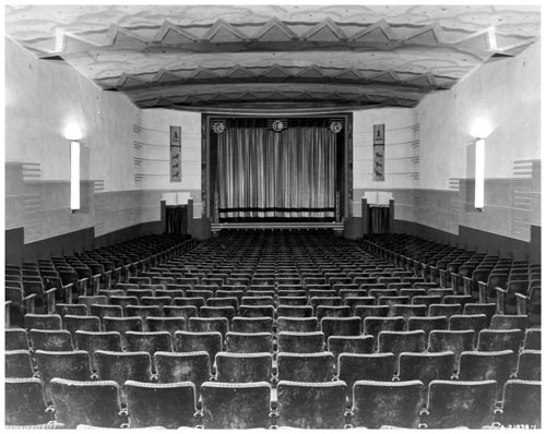 | Circle Theatre auditorium and screen in North Toronto 1933-1956 (Categorized under: Midtown theatres ) 79 years ago - 1947 - Sherwood Park Link to archive record - Map location (From Archives of Ontario) |
| 1947 | | Sherwood Park - walking east down the hill towards the river 79 years ago - 1947 - Sherwood Park at 190 Sherwood Ave west of Bayview Ave Link to archive record - Map location (From the City of Toronto Archives) |
| 1955 | 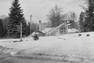 | Manton Florist and greenhouses - run by Thomas Manton, across from the Blythdale Greenbelt at Blythwood and Stratford Crescent 71 years ago - Saturday, January 1, 1955 - Sherwood Park at 502 Blythwood Road n.e. corner at Stratford Crescent Max temp: 5.0°C - Min temp: 1.7°C - 1.0cm of snow on the ground (weather details) Link to archive record - Map location (From the Toronto Public Library) |
| 1955 | 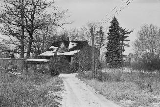 | Thomas Manton house next to his greenhouses on Blythwood Road 71 years ago - Saturday, January 1, 1955 - Sherwood Park at 502 Blythwood Road n.e. corner at Stratford Crescent Max temp: 5.0°C - Min temp: 1.7°C - 1.0cm of snow on the ground (weather details) Link to archive record - Map location (From the Toronto Public Library) |
| 1965 | 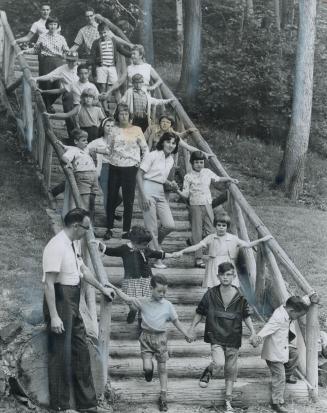 | Day camp run by the Canadian National Institute for the Blind (CNIB) in Sherwood Park 61 years ago - Saturday, July 24, 1965 - Sherwood Park at 190 Sherwood Ave west of Bayview Ave Link to archive record - Map location (From the Toronto Public Library) |
| 1981 | 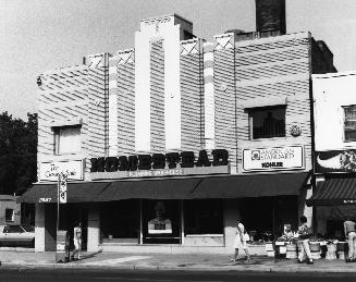 | Circle Theatre (1933-1950s) on Yonge St. - Homestead Plumbing Warehouse at the time (Categorized under: Midtown theatres ) 45 years ago - Saturday, August 8, 1981 - Sherwood Park at 2567 Yonge Street east side between Sherwood Avenue and Sheldrake Boulevard Link to archive record - Map location (From the Toronto Public Library) |
| 2016 | | Footbridge in Sherwood Park - east side of park towards Bayview Ave 10 years ago - Thursday, June 23, 2016 - Sherwood Park at 190 Sherwood Ave Link to archive record - Map location (From the City of Toronto Archives) |